Posts

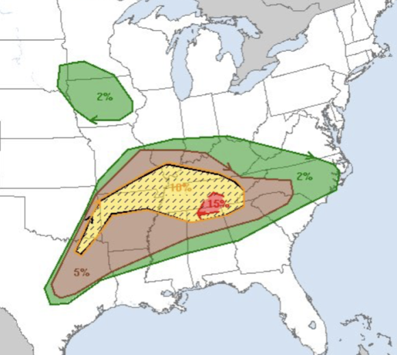
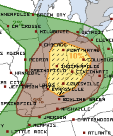
Tornado and Severe Thunderstorm Outlook for Thursday

Image
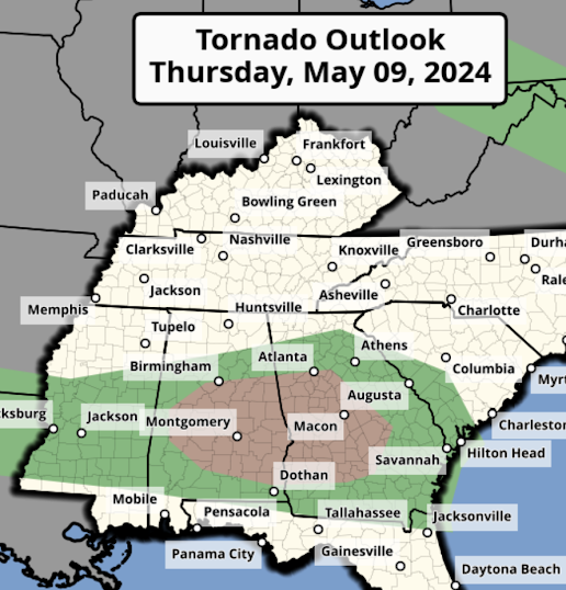
We have one more day of tornadoes and severe thunderstorms and then Mother Nature will be giving us a break.  Tornado Forecast The area in brown has a significant risk of tornadoes.  Damaging Wind Forecast The hatched area has the potential for winds of 75 mph or stronger along with power outages. The unhatched areas have the potential for gusts of 60 mph or stronger.  Large Hail Outlook The hatched area is where hail stones 2" or larger are forecast to fall.  I will update this outlook Thursday morning.

Overnight Tornado Forecast Update 8:50pm CDT

Image
After another eight hours, this ends my coverage for the night. Below are forecasts for the remainder of the night, please look them over.  Tornado Forecast for the Rest of the Night In the red, there is a high  risk of tornadoes, some strong, between now and 1am The yellow hatched area is where there is an enhanced  risk of strong tornadoes the rest of the night.  The brown area has a significant risk of tornadoes until 7am Thursday New Tornado Watch Until 3am CDT Thursday This is one of the most extraordinary radar images I've ever seen. This is the Dopper wind velocity data for the east half of Tennessee and far northern Alabama. I've the circled the rotation for each of the tornado warnings (red polygons).  809p CDT Severe thunderstorm and tornado risk increasing as more storms from from around Dallas to points northeast. Please monitor the area in the red outlined area.  Above is the radar and tornado watches (amber) as of 7:10pm. Storms are developing from Dallas County

Midwest Tornado Watches

Image
8:02pm (EDT) Tornado Watches The tornado watch has been extended down the lower Ohio Valley to SE Missouri. For some reason, the earlier tornado watch near Chicago did not cancel properly. 7pm tornado watches 6:08pm tornado watches map Here is the latest tornado watch map. Please keep up on the latest weather information.  Below is the composite radar as of 3:10pm CDT. Amber is the tornado watch and yellow = severe thunderstorm warnings.  I'll update from time-to-time on Twitter @usweatherexpert. 

The Extreme Tornado Risk Forecast: The Day After

Image
Today is the day after one of the most urgent tornado forecasts in years.  I validate my forecasts rather than the NWS's. If you scroll down, you'll see the forecast I made Sunday afternoon and the tornadoes reported, so far. I predict that in three days -- after the NWS's field surveys-- the number of red dots will double. Three of the existing red dots are of the violent, fatal tornado that destroyed much of Barnsdall, OK and did significant damage in Bartlesville. The Oklahoma side of the forecast was pretty good. I suspect the enhanced area (red) and significant (orange) will work out when all of the reports are in.  The one area that didn't work out? The Kansas side of the extreme risk, including my home of Wichita.  When it comes to weather forecasting, people's emotions often invert. The late meteorologist Allen Pearson used to tell a joke about a "little old lady" who mistook tornado watches for warnings. Lady calling on phone, "You kept me in

Today and Wednesday's Tornado Risks

Image
There is an enhanced tornado risk in the Midwest today. The yellow, hatched area has an enhanced  risk of strong  tornadoes. The brown area has a significant risk. The preliminary tornado forecast for Wednesday also has a significant risk of strong tornadoes.  Of course, I will update these forecasts. I'll have comments about yesterday's forecast later this morning. 

Note to Readers: Midnight

Image
After 17 continuous hours of storm coverage, I'm going to have to end for the night.  Barnsdall, OK was struck by a violent tornado. There are reports of extensive damage and unconfirmed reports of fatalities.  Bartlesville, OK has significant damage. Don't know about injuries.  There is a chance of tornadoes in the Midwest Tuesday and a larger risk in the Midwest and South on Wednesday. Please check back in the late morning Tuesday for my updated forecasts. 

5 Tornado Watches in Effect

Image
Tornado Watch until 5am. Tornado Watch until 4am. Tornado watch till 3am.  Also, a new tornado watch (third of the day) has been issued for parts of Iowa, Kansas and Nebraska.  3:30pm:   The area depicted on this map has a rapidly increasing risk of tornadoes during the night 60  to 90 minutes. A rare "particularly dangerous situation tornado watch" is now in effect for parts of Kansas, Oklahoma and Texas. This includes Wichita, Oklahoma City and Wichita Falls. Take this seriously! This watch has expired.  At 11:44pm, thunderstorms are developing from Gove KS to Cambridge NE. They will intensify.  -------- I can't emphasize how much I hate days like this. Violent tornadoes are likely  which means that if people are not in shelter and they are hit, serious injuries will result. In 14-days, it will be eleven years since the last EF-5 tornado -- the longest interval ever. Unfortunately, it is possible that record will be broken today. The above is not to frighten you, it is